Thursday, November 8, 2012

Expedia Place Summary Statement

(I have called the proposal Expedia Place as it reflects an experiential journey undertaken by a large group of varying users)

The inevitable projection of urban issues, particularly that of population growth, has placed social sustainability at the forefront of design in the year 2030. The recent emergence of an inverted Brisbane CBD has resulted in residential functionality becoming physically central, while the commercial zone shifted outwards. This transition has set the foundation for the potential to form a complete community that thrived on mixed social activities. This was made possible through the CBD vehicle ban, creating a purely pedestrian location that has begun to regain its connection with the natural environment. 

Expedia Place reflects this vibrant evolution of the modern day city by providing for the new urban needs and values, as well as for the indeterminacy of the future. The centre is a complete redevelopment of the former Myer Centre that absorbs and provides for its environment rather than merely existing within it, aiding in the realisation that modern cities have started to lose touch with nature.


Spatial Allocation and Transition


As can be seen from this section, the three separate parts of the building have evidently different functions, yet the spaces still flow from one to another despite the need for vertical transition. For maglev users to reach the ground floor, they must traverse the ramps that bypass the retail area of the building, providing a visual interaction. Even so, there are multiple directions and paths to choose from to continue the concept of free circulation between spaces. This allows direct or indirect routes to be taken, allowing the building to be utilised for exploration and mixed use, or strictly as a thoroughfare between planes.  


This diagram creates a visual representation of the different zones that cater towards different types of users. Yellow is a mixed zone, blue is a non-cbd resident zone on level with the maglev stations, and green is for residents as it is located on the ground level where these users would always access the building, unless arriving from a trip out of the CBD. I have created a series of vignettes that follows each of the user types on their separate journeys through the building.

CBD Resident


Non CBD Resident


As can be seen, some of the locations overlap, including the roof space. This is because the spaces transition into one another and there are no physical barriers for space and activity allocation to allow a successful mixed use building that forms a complete community

Connectivity

As mentioned earlier, the location of the Myer Centre was key to its acquisition as the site for the future proposal due to its positioning at the cusp of the new residential and outer commercial zones. This meant that it is situated next to a maglev station, which started the entire intiative for using the building to provide an additional level to CBD circulation.   


Because of this raised level occupied largely by non-CBD residents, the potential for a city-wide network is formed that could be a possibility for an even further future scenario. Below is a diagram demonstrating possible connections that may be introduced. 


The image below shows the view from the maglev station situated to the south of the redeveloped myer centre.


Final Floor Plans


My final ground floor plan ended up having more elements than initially planned as it was pointed out that grass would only grow in certain areas due to limited natural sunlight. In order to counteract this reduction in the ability to use grass (I used mulch in most areas instead), I utilised a lot of timber decking and pathways to add more usable space that still felt natural. Many trees and other plants could still be used paired with the timber as well as many species don't require a lot of sunlight. All areas except the north corner and south west edge are directly accessible to the street which enabled a successful parkland type space to be created where users (particularly CDB residents) don't feel that they are in or underneath a building. 

I kept the interior retail levels very similar to how I initially planned as the individual shops show a subtle yet important transition towards a new way of functioning. By maintaining small spaces without extensive storage or back access, the tenants are forced to limit their products and purchase only what they believe they will sell in the near future. This will reduce waste spatially as well as materialistically.

The roof space ended up similar to the ground space, intended as a parkland inspired area. The curved hills, hollowed out by restaurants and cafes, provides an organic feel backed up by the large grass cover. This three dimensional floor plan can be seen below.


Final Facade and Roof Decision

After experimenting with multiple possible facade shapes I decided upon a fairly simple, modified rectangle that angles up and outwards on two sides to create faces that appear to open vertically to provide the illusion of more interior space. The reason for maintaining the simple shape was that it worked most effectively with the expansion and retraction that was required to manoeuvre around the extensive ramps.


I also decided to leave the roof space open, as when I tried placing the facade over the roof area, it appeared very enclosed and small, which is the opposite of the atmosphere I intended. This also allows an unobstructed view towards the river to increase the focal connection to the surrounding environment.


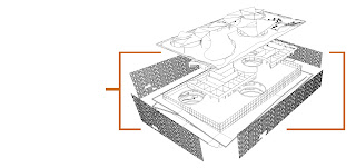
I have produced a diagram that more adequately demonstrated the separate elements used in the construction of the overall building, where the facade makes up the outer, most adaptable and easily removed aspect of the structure. As discussed in an earlier post, the permanent interior grid (created from the skeleton of the original Myer centre structure with removed lower floor plates) is kept simple for the ease of space reassignment in the future. The interior retail walls are non-load bearing to allow for easy restructuring in the future if the functionality of the building is to change. By have such a combination of elements, the building will last for many years and can be re-purposed numerous times for a large variety of activities. 

The facade is composed of three varying bronze aluminium mesh panels that can be stacked and transported to the site for installation. Here they are bolted together and attached to mechanical sliding tracks located alone the bottom of the floor plates and ramps to provide the required inward and outward movement of the facade. 


Here you can see the facade extended during normal hours to provide more interior space while the outer ramps are less likely to be used as a direct thoroughfare. This also allows more space for edge activation  such as the cafe and seating in this image.


This image portrays peak hour when the facade is retracted, as many workers and visitors are entering or leaving the city via maglev and require the extra ramp space as a thoroughfare. This reiterates the focal point of social sustainability and its importance in the future as population growth continues at a rapid pace, requiring direct actions to be taken to maintain a high quality of life in the modern day city.


As mentioned beforehand, I removed the facade from directly above the building, so to protect users from the harsh sun in the summer I provided multiple shading structures, which also ended up acting as a partial cover to the light tubes. This also means that in the winter the direct sun will be beneficial for passive heating.


As the shade structures consists of layers of angled triangles, strong rain is slowed down to prevent horizontal rain from entering unwanted parts of the building by directing it downwards into the light well to successfully produce the sought after interior rain effect.